
01 02 03 04 05 06 07 08 09 10 11 12 13 14 15 16 17 18 19 20 21 22 23 24 25 26 27 28 29 30 31 32 33 34 35 36 37 38 39 40 41 42 43 44 45 46 47 48 49 50 51 52 53 54 55 56 57 58 59 60 61 62 63 64 65 66 67 68 69 70 71 72 73 74 75 76 77 78 79 80 81 82 83
Chicory is a web-based application to provide information on the make-up of the ArcNet PACs and to facilitate access to the underlying data layers of the ArcNet Marxan analysis.
To access this information from the Chicory landing page, either choose a PAC from the map on the left or from the list on the right. Clicking a PAC in the map reveals options to either view the PAC report (Details) or a report on the oceanographic background of the region. Clicking a PAC’s number from the list will open the PAC report directly.
CF report for every conservation feature (CF) in the selected PAC is provided.
The PAC report summarizes key metrics of the selected PAC. The PAC report Maps, Dashboard, and CF table are explained here.
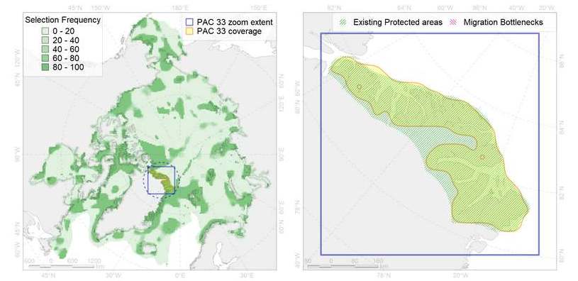
An overview map (left) and closeup (right) show the selected PAC in the context of the study area as a whole, existing protected areas, and migration bottle necks. Note the blue bounding box provided in both maps for scale.

An array of summary statistics for the chosen PAC, including:
| Parameter | Description |
|---|---|
| % of total ArcNet PAC area | A comparison between the selected PAC area and the total combined area of all ArcNet PACs. |
| % of the largest PAC area | A comparison of the area of ArcNet’s largest PAC (PAC 54) to that of the selected PAC. |
| % covered by existing protected area | The percentage area of the selected PAC that is covered by existing protected areas. |
| CFs in the selected PAC | The number of CFs found in the selected PAC. |
| Thematic Group Diversity (% of the ArcNet total for each thematic group) | Breaks down the PAC’s CFs as percentages of the total ArcNet CFs for each thematic group. |
| CFs entirely within the PAC area | The number of CFs that are completely contained within the selected PAC area. |
| CFs at least 25% within the PAC area | The number of CFs that are at least 25% contained within the selected PAC area. |
| CFs whose targets are achieved in the PAC | The number of CFs whose targets are met entirely in the selected PAC. |
| CFs with at least 50% of their target achieved in the PAC | The number of CFs whose targets are at least 50% met in the selected PAC. |
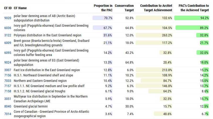
A table of the CFs found in the selected PAC with some basic information, including:
| Parameter | Description |
|---|---|
| CF ID | Unique CF ID number, which is linked to the CF report giving relevant metadata. |
| CF Name | CF name and description. |
| Proportion in the PAC | Percentage of the whole CF extent that is captured in the PAC. |
| Conservation Target | Proportion of the CF that, as a minimum, was to be included in the final Marxan scenario. |
| Contribution to ArcNet Target Achievement | The contribution of the CF extent captured in this PAC to the ArcNet target achievement. |
| PAC’s Contribution to the Achieved Target | The contribution of the PAC to the actual target that was achieved in ArcNet. |
Note that only CFs with more than a 5% contribution to the achieved target (last column in the CF table) are listed in the PAC report. See Accenter for a list of all CFs in the PAC.
Finally, a report is provided for every CF in ArcNet, and these are accessible via the PAC reports and Accenter Conservation Features tab via the CF ID link. The CF reports include:
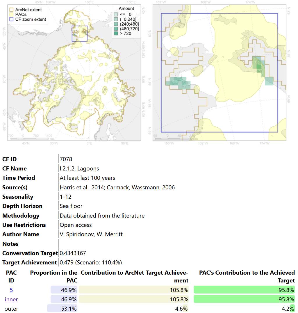
An overview map (left) and closeup (right) are provided as previously with the blue bounding box for scale.
Any available metadata are provided beneath the maps.
The table at the bottom provides relative distribution and target achievement of the CF between the different PACs as well as within (inner) and outside (outer) the ArcNet PACs. Note the inner link accesses a PAC report for the whole ArcNet PAC network.